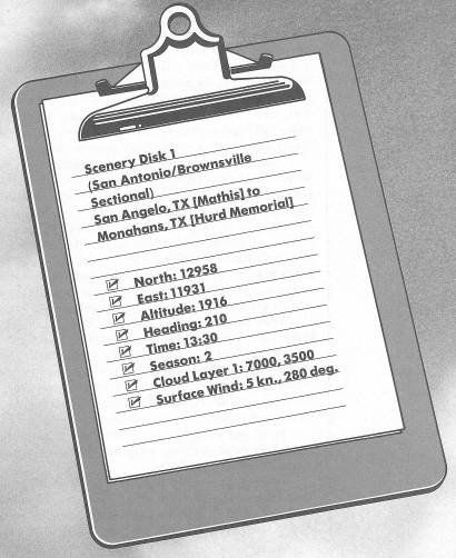
Runway USA
A pilot's guide to destination cities in Flight Simulator
by Charles Gulick
On the Misleading Edge
The sky's still overcast, but we'll fly under it. The wind's shifted around to the west, so we'll take off over Twin Buttes Reservoir.
This is sheep-raising and goat-raising country we're sitting on here. Our destination is Hurd Memorial Airport, Monahans, Texas, but we'll take a little detour so you can see some Great Plains country, and two real lone-prairie cities. There isn't much else to see out there, where people mostly grow wheat and cotton and cattle, and eat a lot of dust. We're lucky we're going in the spring, because in winter the “blue norther” winds might pick this airplane off the ground and end-over-end it right down to Mexico.
Taxi ahead and get lined up, but put your brakes on and hold at the end of the runway. Go into radar and zoom so that you see the whole reservoir ahead of you. Notice the sharp finger pointing to one o'clock. We're going to take off and fly right along the finger, in the direction it points. Our cruising altitude will be 2900 feet. It'll be straight climbout, then a slight right turn to follow the finger, which you'll see distinctly when you're out over the water. Check your progress on radar, and get the pointed tip of the finger like an arrowhead right in the center of your windshield.
That's San Angelo off to your right, sitting beside O.C. Fisher Lake. The lake is fed by the North Concho River.
Once you're level, tune your NAV to Midland, 114.8. Set the OBI to the heading you're on. You won't be in range of the station yet, but stay on your course. When it does get active, you'll find you're on or close to the 288 radial. That finger we followed points almost straight to Midland.
There isn't much to see way out here. If you fiddle around with radar, you'll see a highway well south of your course, Interstate 10 to El Paso.
There are fewer than a handful of towns all along our route. Off to the north, on U.S. 87, are the towns of Carlsbad and Water Valley. To your left, about 40 miles from Midland, is St. Lawrence. A bit further on, Garden City is off your right wingtip, followed by Glasscock. Then, about 15 miles from the OMNI station, we will fly almost directly over Spraberry, Texas.
Don't let your altitude slip away around here. Keep it between 2900 and 3000 feet, or you may thresh some wheat.
Eventually you'll see a highway, Interstate 20, appear on the horizon.
The city that appears ahead of you when your DME reads about 51 is Midland, Texas, a hair to the right of the radial. Twenty miles later you'll see another city, named Odessa, on the horizon.
Admire them now, from a distance, because you won't see them up close. Like other features on the edges of the sectional charts, Midland and Odessa evaporate before our very eyes. Ghost towns. Wraiths of the Great Plains. And the OMNIs just turn off, as if they were never there. Stay on your heading until it happens (after the disk access).
So what do we do now?
First of all, let's see if we can escape no-person's-land. Turn left to a heading of 210 degrees and fly for a minute or so. There'll be another disk access. Then look out the right side, and on radar.
Presto! Midland and Odessa again. And we're headed down Interstate 20.
Turn to the right now, using radar as a guide, until you're paralleling the highway, heading about 234 degrees.
We're going to sneak along Interstate 20, trying to avoid the wipeout that results if we get too close. Monahans is this side of it, and just below the point where the highway bends to the right. You can see the bend on radar.
The elevation at Monahans is 2614 feet, so we'd better climb. Take her to 3400 feet, so the clouds are sitting right on your shoulders.
If Hurd Memorial Airport, Monahans, is on this sectional, we certainly should be able to land there, even if we couldn't fly over Midland and Odessa. Possibly Midland is blacked out for some sinister reason by the oil cartel. It's the center of the Permian oil basin, and a hideout for hundreds of big oil companies. Odessa (rhymes with don't messa), on the other hand, is a rough-and-tough town where all the oil is in the engines of pickup trucks.
Nothing seems to move at all on the landscape for quite a while. But keep a lookout to your right. And keep correcting to the right to stay as close to the highway as you dare.
As the wind indicates, land on Runway 30 at Hurd Memorial Airport. I don't care what kind of pattern you fly. Just don't miss, whatever you do or you will have to refly the approach. We're at the very edge here. Of everything.
Table of Contents | Previous Chapter | Next Chapter