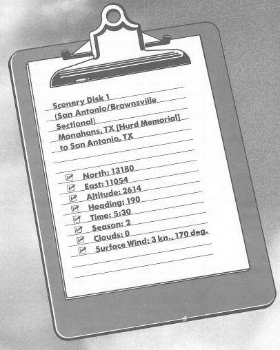
Runway USA
A pilot's guide to destination cities in Flight Simulator
by Charles Gulick
Out of the Dark
I know it's early in the morning, but it'll be daylight when we get to where we're going.
I'm sure this airport is very nice in the real world. But in the world we're flying in I think it's jinxed, and so are all the airports on the edges of the sectional charts.
Nonetheless, we'll fly into and out of them and take our chances. Why take chances? For the same reason people climb mountains.
We're pointed right up Runway 19. But if you check radar you'll see that we're already halfway up the runway. And as oldtime pilots say, there's nothing as useless as used-up runway.
The situation calls for a short takeoff—really short. We'll have to be airborne with a run of about 1200 feet. The sooner we're up the better.
Be sure you remember your takeoff procedure, the trim, the flaps, when to rotate, and all that good stuff. If not, tell me and I'll take us off.
Now let's move and as soon as you get some altitude, turn left to a heading of 130 degrees.
Then just keep climbing, leveling off at 5500 feet (from where we were, that's not very high up).
For your last glimpse, for a while, of civilization, be sure and look back at Hurd Memorial Airport. The runways form a pretty crisscross. Or is it double cross?
The line slicing your view is a highway, not a horizon. It's our old friend Interstate 10.
Tune your NAV to Laughlin VOR, 114.4, to be ready when it comes within range.
It may not look it, but you are gaining on the highway. And don't worry that you're missing anything on the ground. There's nothing to see down there. Three unsimulated mountains—Castle, King, and Tabletop—to the left of your course, each around 3000 feet high. A few small towns—Royalty, Grandfalls, Imperial, Girvin, Rio Pecos, and, directly on Interstate 10, Bakersfield. Then just prairie.
Watch for the dawn's early light at six o'clock.
Isn't that beautiful?
As you leave Interstate 10 behind, it continues on to San Antonio, where we'll head later in this extended flight.
Check your DME regularly. When it turns on, center your OBI needle and fly the indicated radial. If you've stayed on course so far, this will happen about 76 miles out, and your new heading will be between 140 and 145 degrees.
You'll have daylight at precisely 6:30 a.m.
And at daylight, lo and behold! There's what we've been flying toward in these wee hours. Directly ahead of you is the big Amistad Reservoir, just a few miles northwest of Del Rio, Texas, situated directly on the Mexican border.
The river off to your right is the Rio Grande, born in the San Juan Mountains of southwest Colorado and flowing nearly 2000 miles to the Gulf of Mexico at Brownsville, the southernmost city in Texas.
If you look at the reservoir on radar, you'll see another river, left of your course, which also flows into the Amistad Reservoir. That's the Pecos. You'll see it out your windshield, too, if you take a left front view.
Turn to head about 150 degrees, so you're approximately midway between the rivers. Use radar for reference. You'll be aiming at the center of the reservoir.
Just above where the Rio Grande flows into the Amistad Reservoir is the town of Langtry, Texas. It wasn't always called Langtry. It was originally named Vinegaroon, for a large scorpion-like spider, native to the area, which emits a vinegarish stench when upset. It was renamed in 1882 by Judge Roy Bean for the British actress, Lily Langtry, mistress of King Edward VII. Bean, who was once chased out of Mexico for cattle rustling, appointed himself justice of the peace in a saloon in Langtry and kept order in the court with six-guns. He was known as “the only law west of the Pecos.” You can still visit Judge Roy Bean Saloon & Museum down there in Langtry, courtesy of the Texas Highway Department.
About where you're pointed, on this side of Amistad Reservoir, is Seminole Canyon State Park, and reaching out in all directions is the Amistad National Recreation Area.
As soon as you can see the city of Del Rio on the landscape out front, head to fly straight over it. You'll also fly over a big portion of the reservoir. Be sure to take views to all sides to get an idea of its size.
Just the other side of the city is Laughlin Air Force Base, whose OMNI we've been borrowing.
When the city of Del Rio is about at the center of your windshield, turn left, heading 80 degrees.
If you're flying Piper, you may need to switch fuel tanks, since we're flying right on to San Antonio International Airport. (Cessna feeds from both wing tanks.)
Tune San Antonio VOR on 116.8. Nothing will happen to your DME or your OBI yet.
By my calculations (hunches), we have more than enough fuel to make it to San Antonio. We could make a stop at Garner Airport in Uvalde, but we'd lose time.
You seem to be pretty sharp this morning, so I'll get a little shut-eye. Hold your altitude, 5500 feet. Watch your DME for contact with San Antonio OMNI. And fly the OBI needle when it happens. You'll see some highways pretty soon: Interstate 10 from the north and Interstate 35 from the south. They converge at San Antonio. Wake me when you're about 30 miles out.
Now we have some work to do. San Antonio tower says the wind is from 280 degrees at 5 knots. Go into the Editor and make the adjustment to: Surface Wind: 5 knots, 280 degrees. The windshift means we'll land on Runway 30R.
Now if you look at your sectional, you will see that Randolph OMNI is somewhat more in line with San Antonio International than San Antonio OMNI, which is well north of the airport.
So tune to Randolph, 112.3, and get a new bearing.
And what do you know! Look at your fuel gauges. That's called in-flight refueling. And you thought only the Air Force did it. The great Editor in the sky must've thought you were starting all over again.
Anyway, I'm convinced we would have made it even if the winds hadn't shifted.
Next—the elevation at San Antonio is 810 feet. Figure pattern altitude at 1800 feet. We're at 5500 feet. (You are, aren't you?) So we have to lose 5500 minus 1800, or 3700 feet, before we enter the pattern. Round it up to 4000 feet.
Our rule-of-thumb start-descent-distance formula is SD = A × 4, where A is altitude in thousands of feet. But the OMNI is beyond the airport by 8 or 10 miles, so let's give ourselves plenty of time and distance: Start your descent when the DME reads 30 miles.
Our target altitude for the approach, remember, is 1800 feet.
Reduce power for a 500-FPM descent. When you can't hit that rate exactly, err on the high side—600 rather than 400, for example.
Keep the OBI needle centered as you descend. The airport will show up almost directly ahead.
Don't change trim until you're at 2800 feet. Then start trading trim and RPM to slow the airplane to pattern airspeed. Keep reducing throttle and applying up elevator or trim, slowing the airplane while you maintain your 500-FPM descent rate.
Turn left, heading 65 degrees to enter the downwind leg. Check your position on radar, as well as out the windshield.
Downwind heading for Runway 30, left-hand pattern, is 120 degrees. Turn right to that heading when the runway is about in the center of your windshield.
Now take a look out your left side and see Runways 12/30 big as life and straight as a die. The far one, of course, is 30 Right.
Put on carburetor heat when you're opposite the end of the runway, and go ahead with your approach. Your base heading is downwind minus 90 degrees.
Use full flaps. Use your turn coordinator and artificial horizon to make your turns, so you keep the end of the runway in sight all the time and just switch views to match your relationship to the strip.
Now, don't forget to take your carburetor heat off after your landing.
Table of Contents | Previous Chapter | Next Chapter