Runway USA
A pilot's guide to destination cities in Flight Simulator
by Charles Gulick
The Right Stuff
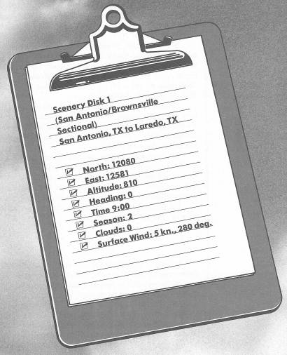
You're looking north.
If you could see 700 miles, you could see the town of Abilene, Kansas, way up there. There are highways, of course—Interstate 35 through Oklahoma, then Highway 135 out of Wichita to Salina, with Abilene a bit to the east of Salina on Interstate 70.
Try to imagine, though, that there are no roads or routes from here to Abilene. No paths or signs. No markings of any kind. Instead, just 700 miles of woods, hills, valleys, brush, grass, and earth; or, if it rains, mud, followed by dust. No bridges. No cities. No towns. No habitation. No stores. No Coke machines. No lights at night.
Further, imagine you're 60 years old, and you're sitting here, not in this airplane, but on a horse-drawn wagon. And you have just made the decision to make your way from San Antonio to Abilene. For the first time ever. Not the first time just for you, but for anybody.
You know you'll have to get across rivers and creeks, and down and up ravines, and your wheels will get stuck, and the sun will get hot and the nights will be dark, and you'll wish you never started. You know you'll look ahead and wonder which way to go on, or whether to go on.
But you made the decision and it's time. So you spit at the wind, pick up the reins, and begin.
In 1866, a year after the Civil War, Jesse Chisholm drove a wagon from San Antonio, Texas (where you're sitting now) 700 miles north to Abilene, Kansas. He went through the heart of Texas and on through what was then Indian Territory, now Oklahoma. He was the first. A year later, Abilene became a railroad shipping center, and the cattle drovers followed Chisholm's trail to Abilene and other Kansas shipping points. His wheel ruts showed them the way, so they named it for him: The Chisholm Trail. At its peak in 1871, more than a half-million cattle were stretched along the route, raising dust that hasn't settled yet.
The trail pretty much parallels Interstate 35 through Austin, Temple, Waco, Dallas-Ft. Worth, Gainesville, and across the Red River to Ardmore, Oklahoma; then on to Oklahoma City and hundreds of miles more, across the Arkansas River at Wichita, and continuing north.
However, this morning we're going the other way, to Laredo, Texas. We'll go about a hundred miles an hour. On the way, think how long it took Jesse to go that many yards, and the courage it took to begin.
Take a 45-degree left view and there's your active runway, 30 Right.
Fire up your NAV and tune to Cotulla, 115.8. Don't set your OBI yet. We will pick up a heading after we fly over San Antonio.
Take off and climb straight out to 1500 feet. The campus of the University of Texas at San Antonio is ahead, just off your nose.
Plan to cruise at 2500 feet, but as you climb, make a wide turn to the right so that you fly back across the airport and head south over the center of San Antonio—about 180 degrees should do it.
The outskirts of the city bristle with military bases. Off to your left is Randolph Air Force Base, then Fort Sam Houston, a big Army complex. Martindale Army Airfield is just the other side of Interstate 10. Ahead to the right are two Air Force bases, Kelly and then Lackland; nothing but a little road (named Military Drive, logically enough) separates them.
At the center of the city, just north of HemisFair Plaza, is the main attraction of San Antonio: the remains of the Alamo. There, on March 6, 1836, after a long siege, 188 Texas defenders—including Davy Crockett, James Bowie, and other Americans, many blacks and Latins among them—died at the hands of several thousand Mexican troops led by General Santa Anna, with the final gasp coming in the chapel of the fort. Three weeks later in Goliad, 75 miles to the southeast, twice as many Texans surrendered on a promise of safe conduct, following a battle on Coleto Creek. The promise was not kept, and they were massacred. Three weeks later, shouting not just “Remember the Alamo!” but “Remember the Alamo! Remember Goliad!,” a Texas army under General Sam Houston defeated Santa Anna at San Jacinto, and independence from Mexico was won. If Americans remember the Alamo, then they should remember Goliad, too; and, along with famous names like Crockett and Bowie, the unnamed and unknown black and white Americans martyred in both these Texas tragedies.
The airport you'll spot on the southern outskirts of town is Stinson Field.
Center your OBI and get a heading to Cotulla OMNI.
The highway out your windshield is Interstate 35. The one going east, visible out the left front window, is the continuation of Interstate 10, on its way to Houston.
You might tune your NAV2 to Laredo VOR, 117.4, somewhere along here, and set its OBI to the heading you're flying. Then, when you're in range, OBI2 will stop reading “Off” and you can tune NAV1 to Laredo for a DME reading. Cotulla VOR is just a stepping stone.
Your aircraft probably won't stick all that well to its altitude on this flight. Just use power and keep adjusting, or trim your elevator a notch, to hold as close to 2500 feet as you can. Down elevator trim is best in such cases, as you've already learned, since it yields an increase in airspeed.
Some of the towns you'll pass are Von Ormy, Somerset, Natalia, Rossville, Devine, Kyote, Big Foot, Moore, Pearsalll, Derby, Divot, Dilley, Millett, and Gardendale. From Cotulla to Laredo the towns thin out considerably, but right on the highway are the towns Artesia Wells and Encinal.
Once you're in range of Laredo OMNI, you'll probably be altering your heading slightly to the south.
Laredo International is this side of the OMNI station and this side of Laredo, on the northeast edge of the city. As chief port of entry from Mexico, one of Laredo's primary businesses these days is likely to be arresting illegal aliens.
We'll set down on Runway 32, using a right-hand pattern. Elevation is 508 feet. You're cleared for direct entry onto base leg, heading 230 degrees. Be sure you're at pattern airspeed and altitude when you enter.
And don't accidentally cross the Rio Grande. You may never get back.
Table of Contents | Previous Chapter | Next Chapter