Runway USA
A pilot's guide to destination cities in Flight Simulator
by Charles Gulick
A Water Idyll
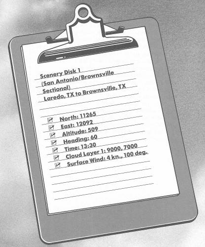
Shades of Monahans! We're in for another fringe trip; this one right along the shores of the Rio Grande to the southernmost city in Texas—Brownsville. These shores are not just those of the Rio Grande, but those of the chart we're flying, as you'll see if you look at it.
Anyway, we have to fly these razor edges, because that's where much of the scenic interest is, because that's where much of the water is.
Go into radar and zoom out until you see the entire shape of Laredo, and the Rio Grande chopping off its lower half. Actually, you're looking at a pair of cities here—Laredo, Texas, and Nuevo (New) Laredo, Mexico.
Now go back to out-the-windshield and get ready for your takeoff.
My idea is to fly on the U.S. side of the river, in a generally southeasterly direction, but keeping the river readily visible all the way so that we don't inadvertently cross it and end up in no-man's land.
The Rio Grande isn't all that spectacular in the simulation, but it will lead us down to that double-headed arrow on your chart, which does look interesting. Beyond that, the river will take us to Brownsville and the Gulf of Mexico, where this long, contiguous trek in and around Texas will terminate, and we'll head for new horizons.
Take off and climb straight out until you have reached 1000 feet. (Yes, that little strip of blue on the horizon, as you climb to the east, is the Gulf of Mexico, believe it or not.) As you gain altitude (plan to level off at 2000 feet), turn right and parallel the river, keeping it at the center of your field of view when looking out the right side. Use radar to check where you're going until the lie of the river is apparent.
When you're at cruising altitude, you'll find that the body of water we're headed for can be seen on radar. Head for the center of it, always staying left of the river as cautioned above. Note that on high-altitude radar, the river will look closer than it really is.
When things settle down, your heading should be in the general vicinity of 160 degrees.
The water we're headed for is Falcon Lake. As it comes closer you can get a better view of it on radar, and before long it will take shape out your windshield, too.
As you near the point where the river flows into the lake, check your position on radar, and, if needed, make a course correction to aim over the lake proper. You'll probably be heading about 150 degrees.
As far as I know, there's only one town all along this stretch, and it's called San Ygnacio. On the northern tip is another town called Zapata, which is also the name of the county we're flying over. I can find no references to the town, but, to be on the safe side as we fly by, yell “Viva, Zapata!” out the left side and “Viva, Villa!” out the right side.
The contours of this lake are a real feast for the eyes, aren't they? Be sure to fly right toward the lake and then down the center of it. Really beautiful, isn't it? Wouldn't it be a shame to have missed it?
I'm really tempted to land right along that point. Once we're over the shaft of the arrow, it seems to stretch ahead forever. I definitely plan to make this trip from Laredo again some day, and land down along the point. It just looks magical, somehow.
While you're cruising along, tune to McAllen VOR, 109.8, but don't set your OBI or change your heading yet. Enjoy Falcon Lake until it slips away under your nose.
Meanwhile, zoom way out on radar, and you'll see another lake ahead, where the river bends to the left and flows toward the Gulf. That lake lies in Mexico and is called Presa M.R. Gomez.
At about the center of Falcon Lake, correct your course (if needed, and probably to the left) to stay on this side of the Rio Grande.
Another beautiful vista lies ahead, composed of the southern tip of Falcon Lake, the resumption of the Rio Grande, and Presa M.R. Gomez in the distance. I really hope you're enjoying this flight half as much as I am. I am totally charmed by the gray sky, the deep green and blue, and the edges of the shore which seem to glitter like diamonds.
As the last point of Falcon Lake works its way off your windshield, it's time to get on the OBI needle for McAllen. You'll probably find the 110-degree radial is the one.
As you bank to get on the heading, you may see some brilliant white bars flash on and off. They'll look, momentarily, like runways or highways as they come on the scene and then vanish.
Try some wing-wagging to view them again.
Well, true, we are heading for a highway (and some more neat water scenics, too). Presently, a few bars of white will link arms on the horizon, stretch halfway across your windshield, and then unlink again.
The highway is one of the few non-interstate routes we find in the simulator: U.S. 77, going north from Brownsville through Harlingen and joining Interstate 37 just west of Corpus Christi.
The city directly ahead, now or shortly, is McAllen.
When your DME reads about 28, retune your NAV, this time to Brownsville OMNI on 116.3, and get a new bearing on your OBI. It'll probably be 102 degrees, but regardless of what it is, fly it.
Now if you access and adjust your radar so that you see the Gulf of Mexico ahead, you'll also see McAllen and a short strip of highway which forms a “T” with U.S. 77. You'll also see the Rio Grande south of the highway and, over in Mexico, a lake named Presa del Azucar. Further, you'll be able to trace U.S. 77 all the way up to Corpus Christi.
Out the windshield again, before long you'll see another great vista ahead. The flat shape of McAllen, Texas, with Miller International Airport on its southern outskirts…the little strip of highway (U.S. 83) from McAllen to Harlingen peeling off to the left and eventually linking with U.S. 77…and beyond Miller International Airport, Presa del Azucar, with the Gulf of Mexico on the far horizon.
You'll fly directly over the city of McAllen. Take a look at Miller International Airport out the right front and side windows. The runways certainly look inviting, but we have promises to keep.
The city of McAllen almost looks like the deck of a carrier out front, doesn't it? One no Navy pilot could miss.
And very soon, there's the city of Brownsville ahead, sitting like a jewel surrounded by blue velvet. Sort of twinkling on and off, pulsing like something alive.
The Rio Grande curls right around Brownsville and into the Gulf of Mexico, through a bay called Port Isabel.
The airport at Brownsville (Brownsville/South Padre Island International) is at an elevation of only 23 feet. We'll land on Runway 13 Left, which is slightly less than 3000 feet long. Just glue your OBI needle to center, and you will be in fine shape.
The tower couldn't do anything but approve a straight-in approach after a beautiful flight like this, could they?
Table of Contents | Previous Chapter | Next Chapter