Runway USA
A pilot's guide to destination cities in Flight Simulator
by Charles Gulick
A Bridge Very Far
Here's a short flight we just have to make—for two reasons. The first is that, according to the Phoenix sectional chart, the runway at Lake Havasu Airport goes right across the lake like a bridge, and I would like to check it out. The second is that just north of the airport in Lake Havasu City lies an unusual entity, which also crosses the lake. I'll bet ten dollars we won't see this amazing object, but at least we'll see where it is, which is better than nothing at all. Maybe you know what I'm talking about, but if not, come on along and find out.
As I write this, I assure you that I'm making my first trip ever to Lake Havasu City. If the entity is simulated, we'll discover that fact together, and I'll be out ten dollars.
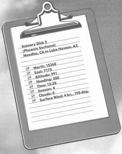
I've lined us up precisely on Runway 20. So all you have to do is take off.
Climb to 1500 feet, turn left to a heading of 130 degrees, and level off at 2000 feet.
The body of water materializing ahead of you is, of course, Lake Havasu. The highway on the horizon—quite a way off—is Interstate 10, which goes east to Phoenix and west to Los Angeles. The Colorado River, presently on your left, forms a natural border between Arizona and California.
Looking on radar, the highway behind you is Interstate 40, and between that highway and the Colorado River is the Fort Mohave Indian Reservation. Though unsimulated, there are mountains on both sides of your course, the Sacramento Mountains to your right side and the Mohave Mountains to your left.
Lake Havasu is not simply a wider segment of the Colorado River. It was created by Parker Dam, about 15 miles south of our destination. Lake Havasu City is a relative newcomer among Arizona communities, and a favorite recreation spot.
The runway at Lake Havasu Airport appears quite suddenly and certainly seems to be as wide as the lake, doesn't it?
Let's cross the river and make our approach to Runway 23 from the Arizona side of the lake. You're on your own now, so fly it as you see it from here on in. The field elevation is 482 feet. Your heading for a right base leg would be 140 degrees, and in the absence of traffic you can enter that leg directly. Also, as you fly, don't forget to keep a lookout for “an unusual entity” this side of the airport.
When you're close, look on radar and you'll see the basis of the illusion, in the chart, that the runway crosses the lake. The runway extends right up to the edge of the lake, to a point where the land reaches out like a bullethead. So don't use up too much runway in your landing, or you may get wet.
When you're on the ground, taxi off the runway and point your nose about 300 degrees.
Out there in front of you is supposed to be—and is, except that it's not simulated—an unusual entity. Something which, unlike the runway, does cross the lake. It's a very special bridge. A bridge which put Lake Havasu City on the map: London Bridge.
In the late twelfth century a priest named Peter of Colechurch designed and built a unique stone bridge across the Thames River in London. It took 30 years to construct and was finally opened in 1209.
One would have to see at least a picture of the original London Bridge to believe it. For it looked more like the architecture on the edge of a fabled city than a bridge. Supported by 20 pointed arches, on piers locked into the river bed by closely-spaced, hard-driven pilings, London Bridge consisted of multi-storied houses and shops soaring toward the sky, all enclosing a wide corridor, which formed the roadway. It had a great stone gate, atop which the heads of both martyrs and traitors were displayed on poles. Smaller boats had a choice of arches under which to pass, and for tall ships there was a timber span that could be opened. The buildings with their chimneys, spires, and weather vanes towered over the highest masts. In its time, which lasted more than six centuries, the bridge was the only dry way across the Thames River.
So how did London Bridge—not the original one, but its genuine descendant—get to Lake Havasu City, Arizona?
Piece by piece, reverently and painstakingly, over the seas from London, after which it was put back together—stone by stone and timber by timber—to span this little lake and form one of America's most unusual tourist attractions.
For Lake Havasu City, Arizona, applause and accolades—that's what I call enterprise.
Table of Contents | Previous Chapter | Next Chapter